



Expropriation Management Platform
Expropriation Management PlatformDigital Expropriation Processes
A system that manages expropriation and land acquisition processes on a single GIS-based platform.
OverviewExplore
How Expropriation Management Platform Works
Expropriation processes are managed on a single platform through integration, value appraisal, registration, notification, settlement, litigation, and payment steps.
Expropriation Management PlatformExpropriation Management Platform
Overview
Expropriation Management Platform: Manage Your Expropriation Management Processes on a Single Platform
Expropriation Management Platform is a GIS-based web software that enables expropriation, urgent expropriation, and land acquisition processes to be carried out in a digital environment.
★
Expropriation Management Platform
360°
provides end-to-end digital process management
Expropriation Management Platform is a GIS-based web software that enables expropriation, urgent expropriation, and land acquisition processes to be carried out in a digital environment.
♦
Highlights
Expropriation Platform
Manage all expropriation processes with a single software. Planning, properties, calculation, value appraisal, notification, settlement, registration, plan changes, reports, managerial information notes, and archive entry
Reduce your bureaucracy costs, reduce the number of lawsuits, transition quickly to the construction stage, and reduce your risks
0172%
0284%
Format Support
It supports formats such as DGN, DWG, DXF, GML, KML, KMZ, NCZ, TAB, and SHP.
It supports formats such as DGN, DWG, DXF, GML, KML, KMZ, NCZ, TAB, and SHP.
0178%
0288%
Detailed Reports
All operations related to valuation, settlement, litigation, payment, and registration processes can be reported through the system.
All operations related to valuation, settlement, litigation, payment, and registration processes can be reported through the system.
0184%
0292%
Capabilities
The Expropriation Management Process
Managed from Start to Finish
- 01.NotificationAutomatic notification and tracking through Turkish Post and Telegraph Corporation integration.
- 02.SettlementAutomatic preparation of settlement and non-settlement records.
- 03.PaymentNotification of expropriation value payments to the finance-accounting unit as a list, or making the payment through online integration.
- 04.Value AppraisalAutomatic preparation of a detailed value appraisal report for every land type, including field, plot, structure, building, garden, facility, factory, special structure, covered agriculture, and greenhouse.
- 05.LitigationLitigation tracking, notification to the legal unit, or opening a screen with authorization and providing integration.
- 06.DamagesProcesses for paying damages and loss of income caused to planted or stored products during the expropriation or construction stage.
- 07.Difference TrackingTracking the differences between payments, value appraisal amounts, and settlements.
- 08.Registration OperationsAll title registration operations.
- 09.Forest OperationsLeasing, easement rights, correspondence, and value operations on forest lands.
- 10.Treasury OperationsLeasing and allocation operations on treasury lands.
Core Competencies
Modules that support Expropriation Management Platform operations
A system that manages expropriation and land acquisition processes on a single GIS-based platform.
Go to OverviewManagement Panel
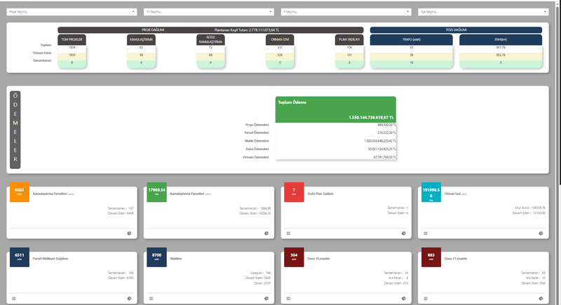
It is the main dashboard where general statistics on expropriation processes are displayed graphically.
Project Registration and Management Screen
It is the screen where expropriation projects are created and managed. When registering a new project, information such as project name, type, status, expropriation type, and relevant institutional decisions is recorded...
Map Data Screen
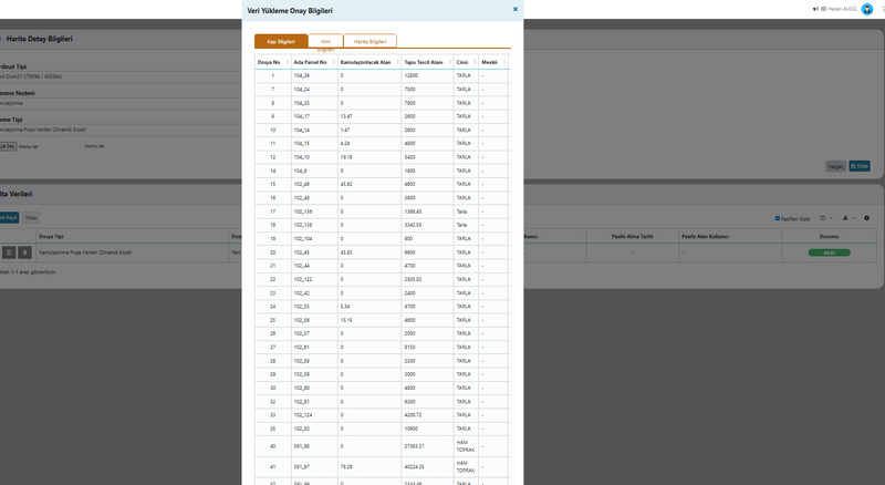
It is the screen where the parcel boundaries and area information of the project are uploaded. By adding KML or map files, users automatically transfer information such as block-parcel, area, type, and map sheet...
Property Information Screen
It is the screen where the title deed, parcel, and attribute information of the properties subject to the expropriation process are recorded.
Owner Detail Information Screen
This screen is the area where all ownership details of property owners are managed. The user can view information such as the property list, share ratios, areas, and expropriation status of the selected person...
Report Information Screen
It is the screen where value assessment reports for expropriated properties are created. The user can view information such as the property’s location, area, expropriated area, actual status, and valuation criteria...
Capability Cards
Everything Expropriation Management Requires,
in a Single Platform
The main modules are organized as concise corporate summary cards within the current page layout.
Management Panel
Management Panel
It is the main dashboard where general statistics on expropriation processes are displayed graphically.
Project Registration
Project Registration and Management Screen
This is the screen where expropriation projects are created and managed. When registering a new project, details such as the project name, type, status, expropriation type, and the relevant institutional decisions are recorded.
Map Data
Map Data Screen
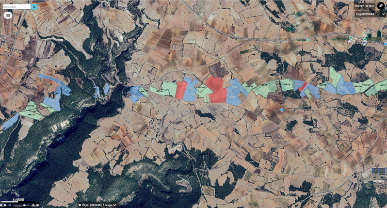
This is the screen where the parcel boundaries and area information of the project are uploaded. By adding KML or map files, users automatically transfer information such as block-parcel, area, land type, and map sheet into the system.
Property
Property Information Screen
The Property Information Screen lets you track, monitor, and manage the relevant process on a single screen, in line with the corporate workflow.
Owner Detail
Owner Detail Information Screen
The Owner Detail Information Screen lets you track, monitor, and manage the relevant process on a single screen, in line with the corporate workflow.
Report
Report Information Screen
The Report Information Screen lets you track, monitor, and manage the relevant process on a single screen, in line with the corporate workflow.
Notification
Notification Operation Screen
The Notification Operation Screen lets you track, monitor, and manage the relevant process on a single screen, in line with the corporate workflow.
Settlement Owner
Settlement List (Owner) Screen
The Settlement List (Owner) Screen lets you track, monitor, and manage the relevant process on a single screen, in line with the corporate workflow.
Kaynaklar
Explore our promotional materials
You can access presentation and promotional content about Expropriation Management Platform from this section.
Product Tour
Explore Expropriation Management Platform
Management Panel
It is the main dashboard where general statistics on expropriation processes are displayed graphically.
Project Registration and Management Screen
This is the screen where expropriation projects are created and managed. When registering a new project, information such as the project name, type, status, expropriation type, and the relevant institutional decisions is recorded.
Map Data Screen
This is the screen where the parcel boundaries and area information of the project are uploaded. By adding KML or map files, users automatically transfer information such as block-parcel, area, land type, and map sheet into the system.
Property Information Screen
This is the screen where the title deed, parcel, and attribute information of the properties subject to expropriation are recorded. The user views or edits data such as the province-district of the deed, block-parcel number, area, map sheet, and location.
Owner Detail Information Screen
This screen is where all ownership details of property owners are managed. The user views information such as the property list, share ratios, areas, and expropriation status for the selected person.
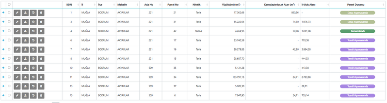
Report Information Screen
This is the screen where value appraisal reports for expropriated properties are created. The user views information such as the property location, area, expropriated area, actual status, and valuation criteria.
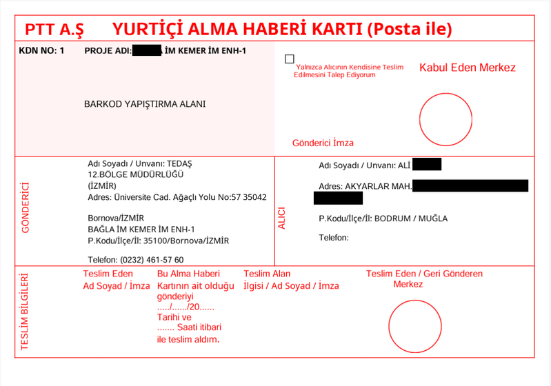
Notification Operation Screen
The preparation, sending, and tracking of notifications addressed to property owners during the expropriation process are carried out from this screen.
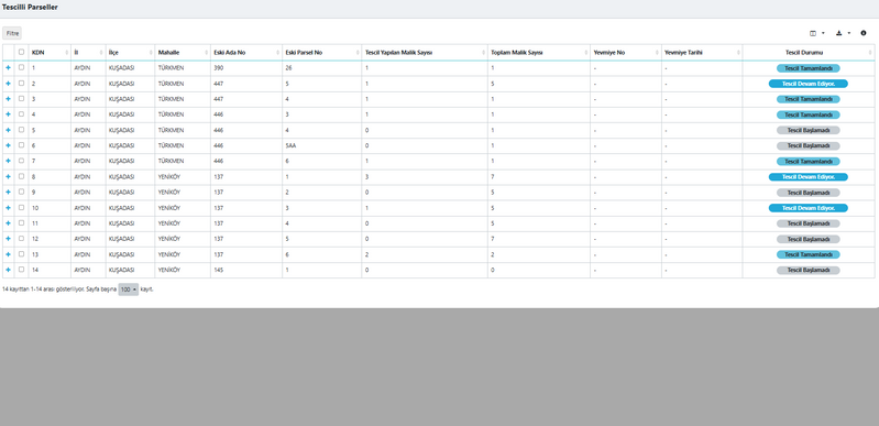
Settlement List (Owner) Screen
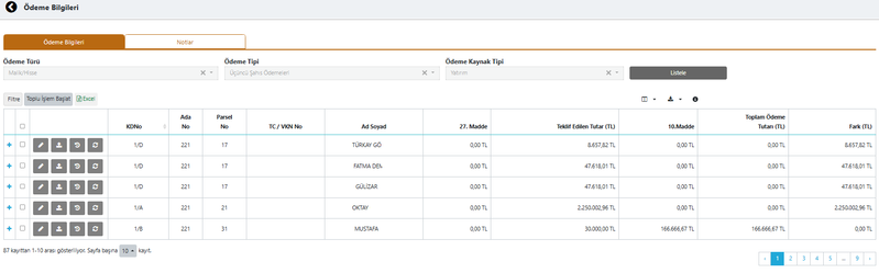
This screen is the section where settlement negotiations are managed on an owner basis during the expropriation process. For each owner, parcel information, share ratio, offered amount, and settlement status are shown in a table.
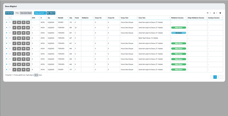
Litigation Detail Information Screen
This is the screen where court and ruling information for lawsuits filed during the expropriation process is recorded. The user tracks the status of the case file, ruling dates, docket numbers, and the determined expropriation and easement amounts on this page.
Payment List Screen
This screen shows a general list of all payment items within the project. Each row includes the payment category, type, source type, transaction date, and payment status.
File Upload Screen
This screen enables the required documents within the project to be uploaded to the system. The user selects the document type from the list and adds the file to the system.
Property Third-Party File Upload Screen
This screen is used to upload third-party documents related to properties into the system. The user selects the document type from the list and uploads the relevant file.
FAQ
Quick answers about Expropriation Management Platform
The core use cases and corporate value of the product are summarized here.
Contact UsExpropriation Management Platform is a GIS-based web software that enables expropriation, urgent expropriation, and land acquisition processes to be carried out in a digital environment.
It allows all properties within expropriation areas to be displayed on a GIS-based map together with their boundary and project information.
All operations related to valuation, settlement, litigation, payment, and registration processes can be reported through the system.
It works fully integrated with Land Registry and Cadastre Information System, Central Civil Registration System, Tax Office Automation Project, Electronic Document Management System, and e-signature services.
It ensures compliance with Expropriation Law No. 2942 and the relevant regulations.
Expropriation is a high-risk operation. The real problems begin after the expropriation is carried out. Even after 100 years, disputes, lawsuits, and claims continue. It allows you to manage data on a permanent technical and legal foundation.
It saves time; it enables investments to proceed at the construction stage with reliable land acquisition information, data, and reports.
It reduces your bureaucratic costs and increases your institution's returns.
Through sustainable land acquisition management, it enables you to deliver secure, legally sound projects in which regulations are applied in a controlled and complete manner.
It increases your overall quality.
It saves time; it enables investments to proceed at the construction stage with reliable land acquisition information, data, and reports.
It reduces your bureaucratic costs and increases your institution's returns.
Through sustainable land acquisition management, it enables you to deliver secure, legally sound projects in which regulations are applied in a controlled and complete manner.
It increases your overall quality.
Expropriation Management Platform
Digitize Your Processes,
Increase Control
Expropriation Management Platform is a GIS-based web software that enables expropriation, urgent expropriation, and land acquisition processes to be carried out in a digital environment.
Map
Format Support
Detailed Reports
Integration Compatibility